This post is to acknowledge the traditional owners of the land in the Inner West. Inner West Council acknowledges the prior ownership of this area by the Gadigal people who were dispossessed by European invasion more than two hundred years ago.
We celebrate the survival of Aboriginal people and their culture following the impact of European invasion and support their right to determine their own future.
There many different groups within the Australian Aboriginal community. The traditional Aboriginal Groups of inner Sydney Ashfield, Leichhardt Marrickville region are the Gadigal and Wangal clans of the Eora nation.
Gadigal land lies south of Port Jackson and stretches from South Head to Petersham with part of the southern boundary lying on the Cooks River. On the western border lies the territory of the Wangal clan, which extends along the southern shore of the Parramatta River to Parramatta.
Suburbs close to the city such as Glebe are also the home of the Gadigal and Wangal ancestors, and the surrounding bushland was rich in plant, bird and animal life with fish and rock oysters available from Blackwattle Bay.
Aboriginal communities in the Inner West region are part of a thriving metropolitan area, forming an important part of Sydney’s cultural and spiritual mosaic.
Ashfield Prior to the arrival of Europeans, the area now known as Ashfield within a broader area Wangal people moved and lived, having migrated from South East Asia and then downwards. Exact numbers are unknown, some research indicates there was between 8000 and 10000 aboriginal people in the broader Sydney region, fluctuating with the seasons and tribal conflict. Their territory was believed to be centred on modern-day Concord and stretched east to the swampland of Long Cove Creek (now known as Hawthorne Canal). The land was heavily wooded at the time with tall eucalypts covering the higher ground and a variety of swampy trees along Iron Cove Creek. The people hunted by killing native animals and fish. Violence is known to have occurred both between tribes and within tribes, in particular towards women.
Leichhardt The history of Aboriginal people in the Leichhardt area is, without doubt, a hidden one. What we today know as the Leichhardt Municipality was once the area inhabited by the Wangal band of the Dharug (Eora) language group. The “Eora people” was the name given to coastal Aborigines around Sydney – Eora means “from this place” – local Aboriginal people used this word to describe to Europeans where they came from, and in time the term became used to define Aboriginal people themselves. Wangal country was known as wanne and it originally extended from the suburbs of Balmain and Birchgrove in the east to Silverwater and Auburn in the west.
The northern boundary was the Parramatta River. Neighbouring Darug bands were the Gadiga to the east, the Wallumattagal on the northern shore of the Parramatta River and the Bediagal to the south. How long the Wangal had lived around Leichhardt is unknown, but we do know that the Dharug were living in the Sydney area for at least 10,000 years before the British invasion in 1788.
Occupation sites are areas that show a concentration of debris associated with human occupation. Rock shelters and overhangs were used to provide campsites sheltered from wind, rain and sun. Charcoal, baked clay, fire blackened stones, food remains (usually shell or bone) and stone tools are commonly found in occupation sites.
Middens composed predominantly of shells are essentially the remains of shellfish meals eaten on the spot by Aboriginal people over a long period of time. Fish and shellfish were the main foods of Aboriginal people living around the harbour, with fishing being an important activity of daily life for both men and women.
In the Leichhardt Municipality 16 midden sites have been identified with 4 being readily accessible to the public. Shell middens can be seen at Whitehorse Point in Elkington Park , Balmain and in Rozelle on the foreshore at Callan Point. The other sites are on private property.
The middens are dated at approximately 4, 500 years old, and are recognised as significant by the Metropolitan Local Aboriginal Land Council and archaeologists. A series of interpretive signs can be found at these sites as well as at Yurulbin Point in Birchgrove, recognising the traditional owners of the Leichhardt area.
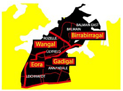
In 2004, following a change in the boundaries of the Leichhardt local government area, Leichhardt Council, in consultation with the Local Metropolitan Land Council, adopted the names Birrabirragal/Balmain, Wangal/Rozelle-Lilyfield, Gadigal/Annandale-Leichhardt and Eora/Leichhardt-Lilyfield for its four ward structure in recognition of coastal Sydney’s Aboriginal history.
Marrickville
The traditional owners of the land are Gadigal of the Eora Nation. The Aboriginal name for the area is Bulanaming.
Gumbramorra Swamp
Following European settlement, Marrickville was a place where runaway convicts could easily hide out in the bush or disappear quietly into the Gumbramorra swamp, which was a natural boundary between Marrickville and what now comprises the suburbs of St Peters, Sydenham and Tempe. The swamp was almost always impassable.
The role of the swamp wetlands played an important part in Aboriginal life as a source of plants and animals. It supported a dense growth of thatch reed, providing an excellent habitat for a variety of birds, particularly swamp hens, moorhens, ducks, gulls and the occasional pelican.
After European settlement its role in the ecological system was not fully understood or appreciated, and the swamp was drained in the 1890s to facilitate the industrialisation of the suburb.
Links
http://www.leichhardt.nsw.gov.au/Library/Local-History/People-and-Places/Eora
https://dictionaryofsydney.org/entry/aboriginal_people_of_the_cooks_river_valley
http://www.gadigal.org.au/our-story.html
https://australianmuseum.net.au/clan-names-chart
http://www.abc.net.au/news/2018-01-24/australia-day-we-will-never-have-a-reason-to-rejoice-this-day/9339738
References.
3.Chrys Meader http://marrickville-heritage.blogspot.com.au/2012/10/marrickville-suburb-history.html